Showing posts with label Bear. Show all posts

Monday, January 25, 2016

Winter Time On The Morice River Houston British Columbia (Pictures/Wolves Video)


Above Photo: Winter on the Morice River Houston, British Columbia.

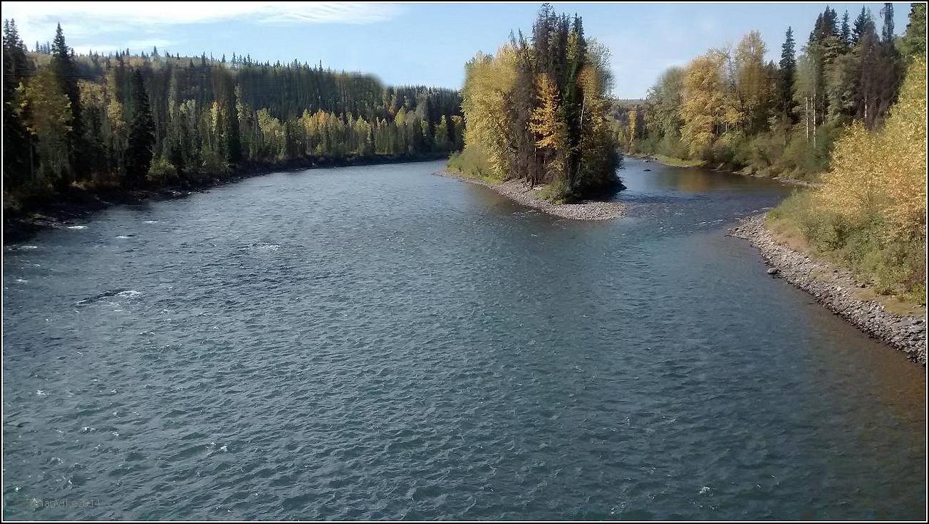
The Morice River holds a lot of good memories for me. The times with the kids fishing on the river, or just exploring different areas on it. The river has a beautiful glacial blue color to it which you can see in one of my photos below. 

I remember one time when three of us launched a twelve foot car top boat at the Lamprey Creek Recreation Site and floated the river. We were armed with fishing rods and mosquito repellent and was the fishing great, it was better than that, it was awesome !


Above Photo: The beautiful glacial blue color to the Morice River, 
Houston, British Columbia.

As we floated along we saw different types of wildlife and the fishing holes were loaded with Salmon, Dolly Varden, Trout and Whitefish and just as you were to float out of one of the holes, there they were just sitting in the fast water, steelhead all lined up ready to make their run up the next portion of the river.


Above Photo: Winter on the Morice River Houston, British Columbia.

The Morice is an amazing river to see, and even better, Morice Lake, now that truly is breathtaking. 

Video Footage of two Wolves running on the ice on the Morice River. The wolves are in the distance when I spotted them, so they look small.

So when you are passing through, or have plans to visit, please drop by our Visitors Centre or send them an email to get all the information on everything Houston, B.C. has to offer.

Houston and District Chamber Of Commerce/Visitors Centre.


Above Photo: Winter on the Morice River Houston, British Columbia.

The text information below from Wikipedia, the free encyclopedia:

The Morice River is the outflow of Morice Lake south west of Houston, British Columbia, Canada. Morice Lake and Morice River are named after Father Adrien-Gabriel Morice. 


Above Photo: Winter on the Morice River Houston, British Columbia.

The Morice has many small creeks joining it along its length, but retains the clear glacial hue for its length. The Morice river continues on to the town of Houston at which point the river is joined by a small tributary river called "The Little Bulkley" and the two rivers joined become the Bulkley River. They become the Bulkley, not the Morice despite the fact the Morice is larger. This was done by Poudrier, a government cartographer whom, it is rumored, never saw the region.


Above Photo: Winter on the Morice River Houston, British Columbia.

Adrien-Gabriel Morice:

Adrien-Gabriel Morice (1859–1938) was a missionary priest belonging to the Oblates of Mary Immaculate. He served as a missionary in Canada, and created a writing system for the Carrier language.


Above Photo: Winter on the Morice River Houston, British Columbia.

Early life:

Born and raised in France, as a seminarian he was inspired by Father Émile Petitot and set himself the goal of becoming a missionary and explorer in Northwestern Canada. He arrived in British Columbia in 1880, and after a stint in Williams Lake at St. Joseph's school, where he studied Chilcotin and, with the aid of Jimmy Alexander, the son of a Carrier woman and a fur trader who was sent to St. Joseph's School, began his study of Carrier.


Above Photo: Winter on the Morice River Houston, British Columbia.

Work with aboriginal languages:

In 1885 his dreams were realized and he was posted to Fort St. James, the fur trading and missionary center in the Carrier region. Father Morice rapidly learned the Carrier language and became the only missionary to speak more than rudimentary Carrier. Within a few months of his arrival he created the first writing system for Carrier, the Carrier syllabary, by making a radical adaptation of the Cree syllabics. From 1891-1894 he published a bimonthly newspaper, the Dustl'us Nawhulnuk, in Carrier. He was responsible for the translation of the catechism and many 
hymns and prayers into the language.


Above Photo: Winter on the Morice River Houston, British Columbia.

From this, Father Morice was the first person to recognize all of the phonological distinctions in an Athabascan language and write it accurately.

He was also the first person to make extensive transcriptions of material in an Athabascan language. His magnum opus was his massive two volume The Carrier Language: A Grammar and Dictionary, which immediately made Carrier by far the best documented Athabascan language of the time.


Above Photo: Winter on the Morice River Houston, British Columbia.

Disputes with the Church:

Father Morice would have preferred to remain in Fort Saint James but in 1904 he was withdrawn by the bishop, who finally paid heed to the complaints of the Hudson's Bay factor. Father Morice proved unwilling to perform the other duties the bishop assigned him and unable to get along with other priests, so after several years of conflict the Church set him up in a house in Winnipeg where he spent the remainder of his life as a scholar, writing extensively on Carrier language and culture, more general Athabaskan topics, the history of the Roman Catholic church in Western Canada, the history of the French and Métis of the West, and occasional other topics.


Above Photo: Wolf tracks on the Morice River road, Houston, British Columbia.

Legacy:

Morice River, Morice Lake, Morice Range, and Moricetown - all located in the Bulkley region of northwest British Columbia, are named in honour of Morice.

Travel British Columbia with Brian Vike blog, please contact me at b_vike@telus.net

Travel British Columbia with Brian Vike.

Travel Houston, British Columbia with Brian Vike.

Thursday, December 10, 2015

The 1012 Pound Hungry Hill Phantom Grizzly Bear Smithers Airport Smithers British Columbia (Picture)


Above Photo: The 1,012 pound Phantom Grizzly Bear from Hungry Hill on display at the Smithers Airport Smithers, British Columbia.

Note about the Grizzly Bear. The bear sits behind glass and I had a heck of a time trying to get any type of a photo due to the reflection from everything else behind me. So this is the best shot I was able to get.

In the Fall of 2001 Conservation Officers caught up with the Hungry Hill Grizzly Bear. It has been reported that this one bear killed upwards of 30 head of cattle in and around Hungry Hill which is located approximately 14 km NW of Houston, British Columbia.

The phantom grizzly bear was one of two grizzly bears that were killed for the downing of a lot cattle. The grizzly killed 30 head of cattle over a three year period.

Some of the cattle that the bear killed were reported to be as much as 1500 lbs. (682 kg). Conservation Officers set out snares and traps, but the grizzly avoided capture 
over a three year period.

Finally in October 2001 Conservation Officers were able to capture the grizzly bear in a 
cable leg hold snare.

As Conservation Officers Kevin Nixon and Brad Lacey approached the bear, it was able to break free the snare and charged the officers. The grizzly was only 7 metres from the two officers when it was shot and killed.

The male grizzly bear weighed 1,012 lbs. (460 kg).


----------

Second Phantom Grizzly Bear from Hungry Hill on display at 
Houston British Columbia’s Visitor’s Centre.

If you would like to view the other (second) grizzly bear that was killed in the Hungry Hill area for killing cattle, you can view this on my Travel blog at: 

Massive 975 Pound Grizzly Bear On Display At Houston British Columbia’s Visitor’s Centre. 

Houston, British Columbia Visitor Centre:


Travel British Columbia with Brian Vike blog, please contact me at b_vike@telus.net

Travel British Columbia with Brian Vike.

Travel Houston, British Columbia with Brian Vike.

Friday, November 20, 2015

Massive 975 Pound Grizzly Bear On Display At Houston British Columbia’s Visitor’s Centre (Pictures)


Above Photo: Massive 975 pound Grizzly Bear on display at 
Houston, British Columbia’s Visitor’s Centre.

I have been trying to get a good picture of the Grizzly bear that is on display in Houston, but seeing it is in a glass enclosure, there is always a reflection to deal with. Today, November 20, 2015 my wife and I stopped by the Visitors Centre and we managed to take a decent photo.

The Grizzly bear that is on display in the Houston’s, Visitors Centre was one of two bear which were given the name of “Phantom Bears”. 

These two Grizzly bears were stalking and killing a lot of livestock around the Hungry Hill area just outside of Houston, British Columbia. One of the bears is on display at the Smithers, B.C. airport, and the other here in Houston. 

The Houston bear is approximately 18 - 22 years old, weighs in at 975 pounds and when the bear is standing, it was 11 feet tall. Again, this bear is on display at the 
Houston Chamber of Commerce and Visitor Centre. 


Above Photo: Massive 975 pound Grizzly Bear on display at 
Houston, British Columbia’s Visitor’s Centre.

The below maps show where you can find Houston’s and Smither’s Grizzly bears.

 You can read about the bears at the below 3 websites.
Western Canadian Game Warden website:

The Hungry Hill "Phantom" Grizzly Bear display in the Smithers airport.

The Phantom of Hungry Hill.

Travel British Columbia with Brian Vike blog, please contact me at b_vike@telus.net

Travel British Columbia with Brian Vike.

Travel Houston, British Columbia with Brian Vike.

Wednesday, November 18, 2015

Coquihalla Highway And The Great Bear Snow Shed In British Columbia (Photos)


Above Photo: The Great Bear snow shed seen from the north end.

For those who have never driven the Coquihalla Highway, you are missing some fabulous scenery and you should make a point of traveling on the Highway. Winter though can put a damper on the drive as the summit gets heavy snowfall and ice. You just have to keep an eye on the weather reports.

Just recently my wife and I made the trip and I am always blown away by what I see. Although the cloud ceiling was low, you still get treated to some awesome sights. I have added a few pictures of what we saw.

Highway Thru Hell TV Series on the Discovery Channel Canada is filmed on the 
Coquihalla Highway in British Columbia.

Also there are Highway cams you can look at to see what the winter weather is like.

Highway 5 cam (Coquihalla) from drivebc.ca.

Weather forecast for Coquihalla, British Columbia.

Below Text Source: From Wikipedia, the free encyclopedia.

South of Kamloops, Highway 5 is known as the Coquihalla Highway (colloquially "the Coq" pronounced "coke"), essentially a 186 km (116 mi)-long freeway, varying between four and six lanes with a posted speed limit of 120 km/h (75 mph). 


Above Photo: Cold Water river.

The Coquihalla approximately traces through the Cascade Mountains the route of the former Kettle Valley Railway, which existed between 1912 and 1958. It is so-named because near Hope, it generally follows the Coquihalla River, for about 60 km (37 mi), and uses the Coquihalla Pass.


Above Photo: Cold Water river.

South of Kamloops, Highway 5 is known as the Coquihalla Highway (colloquially "the Coq" pronounced "coke"), essentially a 186 km (116 mi)-long freeway, varying between four and six lanes with a posted speed limit of 120 km/h (75 mph). 

The Coquihalla approximately traces through the Cascade Mountains the route of the former Kettle Valley Railway, which existed between 1912 and 1958. It is so-named because near Hope, it generally follows the Coquihalla River, for about 60 km (37 mi), and uses the Coquihalla Pass.

Highway 5 begins south at the junction with Highway 3 at uninhabited "Othello", 7 km (4 mi) east of Hope (named after a nearby siding on the Kettle Valley Railway, which used many Shakespearean names). Exit numbers on the Coquihalla are a continuation of those on Highway 1 west of Hope. 


Above Photo: Mountain of rock rises up to meet the clouds.

The speed limit on the Coquihalla Highway south of Merritt is 120 km/h (75 mph). 35 km (22 mi) north of Othello, after passing through five interchanges, Highway 5 reaches the landmark Great Bear snow shed. The location of the former toll booth is 13 km (8 mi) north of the snow shed, passing through another interchange and the 1,244 m (4,081 ft) Coquihalla Pass. 

Highway 5 was the only highway in British Columbia to have tolls, a typical passenger vehicle toll was C$10. Now free to drive, at the Coquihalla Lakes junction, the highway crosses from the Fraser Valley Regional District into the Thompson-Nicola Regional District. 61 km (38 mi) and five interchanges north of the former toll plaza, the Coquihalla enters the city of Merritt. There it joins Highway 5A and Highway 97C.

Highway 5 travels 4 km (2½ mi) through the eastern area of Merritt before reaching its northern junction with Highway 5A. From there, the Coquihalla has three more interchanges and one mountain pass – the Surrey Lake Summit – in the 72 km (45 mi) between Merritt and its end at a junction with Highways 1 and 97. 


Above Photo: Seen from a rest stop on the Coquihalla Highway.

Highway 5 continues east for 7 km (4 mi) concurrently with Highways 1 and 97, through Kamloops. This stretch of road, which carries 97 South and 5 North on the same lanes (and vice versa), is the only wrong-way concurrency in British Columbia.


Above Photo: Seen from a rest stop on the Coquihalla Highway.

After separating from Highways 1 and 97, Highway 5 proceeds north for approximately 19 km (12 mi), temporarily leaving Kamloops city limits as a four-lane highway, before re-entering the city at the Rayleigh community, then continuing north. It becomes a two-lane highway at Heffley Creek and the exit to Sun Peaks resorts, both of which indicate the final northern boundary of Kamloops.


Above Photo: Seen from a rest stop on the Coquihalla Highway.

Highway 5 follows the North Thompson River north from Heffley Creek for approximately 54 km (34 mi), along a parallel course with a branch of the Canadian National Railway, passing through Barriere, to a junction with Highway 24 at Little Fort. 30 km (19 mi) north of Little Fort, while continuing to follow the North Thompson and the CN Railway, Highway 5 then reaches the community of Clearwater. 


Above Photo: This small waterfall was seen right behind the rest stop on the Coquihalla Highway.

It proceeds northeast for another 107 km (66 mi), passing Vavenby and Avola en route, to the community of Blue River; then 109 km (68 mi) further north through the Columbia Mountains, it crosses into the Regional District of Fraser-Fort George, passing by the community of Valemount to its northern terminus at Tête Jaune Cache, where it meets Highway 16.

Travel British Columbia with Brian Vike blog, please contact me at b_vike@telus.net

Travel British Columbia with Brian Vike.

Travel Houston, British Columbia with Brian Vike.

Wednesday, October 21, 2015

Mural Paintings Of Bear and Fisherman Trying Their Luck Houston British Columbia


Above Photo: Mural painting of a fisherman trying his luck.

Here are a couple of Mural Paintings on the outside walls of businesses here in Houston, British Columbia. I really enjoyed looking at them, so I thought I would post the murals for you to look at as well.


Above Photo: Mural painting of a bear fishing in Houston, British Columbia.

If you have a picture or story you would like to share on the Travel British Columbia with Brian Vike blog, please contact me at b_vike@telus.net

Travel British Columbia with Brian Vike.

Travel Houston, British Columbia with Brian Vike.

Wednesday, July 22, 2015

Bulkley And Morice Rivers Are World Class Steelhead Fishing (Pictures)


I reside in Houston, British Columbia and I enjoy taking pictures of our beautiful area. 

This really is a hikers play ground. The fishing is incredible, and the Morice/Bulkley Rivers are world class Steelhead rivers and tourists from around the world come to fish our waters.

Campers come to enjoy the many lakes and rivers, wildlife is abundant, from Black bear to Grizzly bears, Moose and deer can be seen walking around town and the scenery is breathtaking.

Photo below: I took the first picture along the Bulkley River in the town of Houston, B.C. 

Also I have added two pictures of the Morice river as it is an amazing color.


If you have a picture or story from around British Columbia and you would like to share it on this page, please contact me at b_vike@telus.net