Showing posts with label Canyon. Show all posts

Monday, April 25, 2016

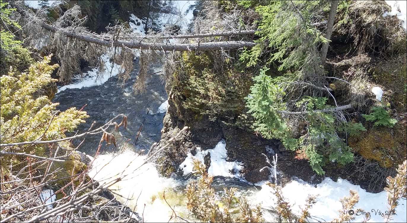
Findlay Creek And Canyon Topley British Columbia (Pictures)


Above Photo: Pictures were taken on April 11, 2016 of Findlay Creek And Canyon Topley, British Columbia. I was also disappointed that I was not able to take photos of the falls as they are something to see, but my body certainly couldn't climb in and out of the canyon.

For larger view of the photos, click on the picture.

The Houston Hikers have a photo of Findlay Falls, and the photo can be 
viewed on their website. Also please take a look around their 
site as they have all the trails covered for you. Link below.

Houston Hikers Society.

For information on things to do in and around Houston, British Columbia, please contact the 
Houston and District Chamber Of Commerce/Visitors Centre. Links below.

Also, I hope you enjoy the photos that I have taken around our beautiful town.


Above Photo: Pictures were taken on April 11, 2016 of 
Findlay Creek And Canyon Topley, British Columbia.


Above Photo: Pictures were taken on April 11, 2016 of 
Findlay Creek And Canyon Topley, British Columbia.

Houston and District Chamber Of Commerce/Visitors Centre.


Above Photo: Pictures were taken on April 11, 2016 of 
Findlay Creek And Canyon Topley, British Columbia.


Above Photo: Pictures were taken on April 11, 2016 of 
Findlay Creek And Canyon Topley, British Columbia.


Travel British Columbia with Brian Vike blog, please contact me at b_vike@telus.net

Travel British Columbia with Brian Vike.

Travel Houston, British Columbia with Brian Vike.

Monday, March 14, 2016

Hagwilget Canyon Near Hazelton British Columbia (Picture)


Above Photo: Taken in the Fall of 2015 – 
Hagwilget Canyon Suspension Bridge crosses the Canyon.

For larger view of the photo, click on the picture.

You can view more photos of the Hagwilget Canyon and Suspension Bridge at the link provided.

Travel British Columbia with Brian Vike blog, please contact me at b_vike@telus.net

Travel British Columbia with Brian Vike.

Travel Houston, British Columbia with Brian Vike.

Sunday, January 3, 2016

Hagwilget Suspension Bridge - Hagwilget British Columbia Vike's Best Pictures From 2015


Above Photo: Hagwilget Suspension Bridge Hagwilget, British Columbia.

I thought I would look back through 2015 and pull out some of my better photos that I had taken from around British Columbia. I know a lot of folks started following me
after my posting about this Suspension bridge.

As my journey continued I came to a spot in the road where my eyes almost popped out of my head. I hit the brakes, pulled the car over to the side of the road, put the transmission into park and jumped out walking quickly to the other side of the road. 

What I stood looking at, was simply amazing, it was the Hagwilget Canyon and Suspension Bridge, and if that wasn’t enough, the colours of Fall made the scene just that much more spectacular. This honestly is a must see for anyone traveling up Highway 16 to the Hazelton’s.

The Hagwilget Canyon Suspension Bridge, the Ksan Historical Village and Old Hazelton is off Highway 16, on Highway 62. Just follow the highway and you will cross the Suspension Bridge and a few more miles down the road, the Ksan Historical Village.


The Hagwilget Canyon is truly breath taking, it is way, way down there into the canyon. As we drove across the single lane bridge, my wife yelled out, holy ****. It was that large of a drop. It is the highest suspension bridge in Canada.

When you cross the bridge, and to your right, you can park your vehicle in a gravel parking lot and walk back and onto the bridge, from there, look down and you will be amazed. 

On your way back to the vehicle, there is an area set aside on the left with park benches so you can just sit and look at the beauty of the canyon and the rugged mountains in the background.

The Hagwilget Canyon and Suspension Bridge ranks up there with many of the best sights to see in all of British Columbia. Do take the time to stop and visit.

For any and all information about the Hagwilget Canyon and Suspension Bridge and other interesting places to see around the Hazelton's, please visit the below links.

Hazelton Area Visitor Centre.

New Hazelton Visitor Centre Tourist Information. (Facebook)


If you have a picture or story you would like to share on the Travel British Columbia with Brian Vike blog, please contact me at b_vike@telus.net

Travel British Columbia with Brian Vike.

Travel Houston, British Columbia with Brian Vike.

Sunday, November 22, 2015

Thompson River Canyon In British Columbia (14 Pictures/Video)


Above Photo: Below is the Thompson River In British Columbia.

One thing I have always enjoyed is traveling along Highway 1 (Trans Canada Highway) through this dry climate. It is so different from here in Houston, B.C. where we are surrounded by green coniferous trees. 

In this drier area what you will see are tumbleweeds, rugged pine and mountains of rock. Also when driving the Highway, keep an eye out for sand hoodoos, as seen in some of my pictures.


Above Photo: Sand hoodoos above the Thompson River.


Above Photo: Blow up of the sand hoodoos picture above the Thompson River.

There isn't much in the way of precipitation throughout the year. Summer temperatures can exceed 35°C (110°F) and in the winter months normally it doesn't seem to get the really cold temperatures and there is very little snowfall.

In one of the pictures my wife took from the car is a Canadian Pacific Railway train traveling through the area. Also on the other side of the river runs the Canadian National Railway. 


Above Photo: Empty Canadian Pacific Railway coal train.

I did manage to take a short video of a empty Canadian Pacific Railway coal train and I posted it to YouTube. You can find the video clip at the below web address.

Canadian Pacific Railway coal train video:

If you enjoy camping or stopping for a picnic lunch, then there is a beautiful area right along side the Thompson River called Goldpan Provincial Park.


Above Photo: Thompson River Canyon and the Canadian Pacific Railway.

Goldpan Provincial Park is a provincial park in British Columbia, Canada, located on the Trans-Canada Highway between Lytton and Spences Bridge, on the Thompson River. The park has camping above the highway and a picnic area and riverfront below.

Goldpan Provincial Park website.


Above Photo: Picture shows how dry it is with tall dry grass and pine trees.


Canadian Northern Pacific's Last Spike.

Canada's third trans-continental rail link was completed near Basque on January 23, 1915. In a simple ceremony the last spike was driven, witnessed by a small group of engineers and workmen.

The line later became part of the Federal Government's consolidated 
Canadian National Railways system.

Province of British Columbia. (1967)


The below text is from Wikipedia, the free encyclopedia.

At Kamloops, the combined Thompson River river flows 15 km from the confluence of the North and South Thompson Rivers before reaching Kamloops Lake, which is roughly 30 km in length, ending at the town of Savona. From there it flows in a meandering course westwards through a 
broad valley area. 


Above Photo: A twisted dried out Pine tree.

At Ashcroft, the Thompson Canyon begins and the river turns southwestward to its confluence with the Fraser. The river is paralleled by the Trans-Canada Highway, the Canadian Pacific Railway and the Canadian National Railway.


Above Photo: A twisted dried out Pine tree and low cloud ceiling.

From Ashcroft to Lytton, the river is completely confined within Thompson Canyon, making for spectacular scenery. The Thompson River joins the Fraser River in Lytton. There is a striking stretch of dark black cliffside just downstream from Ashcroft and visible from the Logan Lake-Ashcroft highway is officially-named the Black Canyon. 


Just below the town of Spences Bridge was the site of a major rail disaster in the early 20th Century. Communities along this section are Bighorn, Shaw Springs, and Goldpan.

Travel British Columbia with Brian Vike blog, please contact me at b_vike@telus.net

Travel British Columbia with Brian Vike.

Travel Houston, British Columbia with Brian Vike.

Saturday, November 21, 2015

Fraser Canyon British Columbia (Photos)


Above Photo: The Yale Tunnel, 286 metres long, just 1.5 km east of Yale.

The Fraser Canyon is an 84 km landform of the Fraser River where it descends rapidly through narrow rock gorges in the Coast Mountains en route from the Interior Plateau of British Columbia to the Fraser Valley. Colloquially, the term "Fraser Canyon" is often used to include the Thompson Canyon from Lytton to Ashcroft, since they form the same highway route which most people are familiar with, although it is actually reckoned to begin above Williams Lake, British Columbia at Soda Creek Canyon near the town of the same name.


Above Photos: My wife took a couple of pictures when driving through the tunnels.

Geology:

The canyon was formed during the Miocene period (23.7–5.3 million years ago) by the river cutting into the uplifting Interior Plateau. From the northern Cariboo to Fountain, the river follows the line of the huge Fraser Fault, which runs on a north-south axis and meets the Yalakom Fault a few miles downstream from Lillooet. 

Exposures of lava flows are present in cliffs along the Fraser Canyon. They represent volcanic activity in the southern Chilcotin Group during the Pliocene period and the volcanic vents of their origins have not been discovered.


Above Two Photos: The mighty Fraser River winds it’s way through the canyon far below.

Geography:

The canyon extends 270 kilometres (170 mi) north of Yale to the confluence of the Chilcotin River. Its southern stretch is a major transportation corridor to the Interior from "the Coast", with the Canadian National and Canadian Pacific Railways and the Trans-Canada Highway carved out of its rock faces, with many of the canyon's side-crevasses spanned by bridges and trestles. 


Above Photo: Spawning salmon statues mark the ends of the Alexandra Bridge.

Prior to the double-tracking of those railways and major upgrades to Highway 1 (the Trans Canada Highway), travel through the canyon was even more precarious than it is now. During the frontier era it was a major obstacle between the Lower Mainland and the Interior Plateau, and the slender trails along its rocky walls - many of them little better than notches cut into granite, with a few handholds - were compared to goat-tracks.

North of Lytton, it is followed by BC Highway 12, then from Lillooet to Pavilion by BC Hwy 99 (the farther end of the Sea-to-Sky Highway, though not carrying that name in this area). The British Columbia Railway (the BC Railway is now owned and operated by the CN) line follows the same stretch of canyon from Lillooet to just beyond Pavilion. 


Above Photo: A deep canyon with a small fast moving creek at the bottom. 
It eventually flows into the Fraser River.

Between there and the mouth of the Chilcotin River there are only rough ranching roads, and the terrain is a mix of canyon depths flanked by arid benchland and high plateau. Between Pavilion and Lillooet, the river's gorge is at its maximum depth, with the river throttled through a series of narrow gorges flanked by high cliffs, though still flanked above those cliffs by wide benchlands which stand on the foreshoulder of the mountain ranges flanking the gorge.

Hells Gate:

At Hells Gate, near Boston Bar, the canyon walls rise about 1,000 metres (3,300 ft) above the rapids. Fish ladders along the river's side permit migrating salmon to bypass a rockslide that diverted the river during the blasting of the Canadian Northern Railway line in 1913. The area around Hell's Gate carries the name Black Canyon, which may either be a reference to the colour of the rocks when it rains, or the name of a community built on the cliffsides here during the Fraser Canyon Gold Rush. 


Above Photo: Cisco Bridges - CPR bridge (black) in foreground, CNR bridge (orange arch) in background. Photo facing upriver. Also a railway tunnel to the left side of the picture.

Today there is a specially-built air-tram, like the kind used in ski resorts, which takes tourists down to Hells Gate, where visitors may view the fish ladders as well as the boiling rush of the Fraser's waters. A set of tourist pavilions with shops and café now occupies the site of the workmen's housing seen in the accompanying image.

View of Hells Gate looking across to east bank, with a CPR steam locomotive in background passing old railway housing, c.1945

At Siska, a few minutes south of Lytton, there are the Cisco bridges—a pair of railway bridges at the throat of a rocky gorge. From south to north, the Canadian Pacific has been on the west side of the canyon, while the Canadian National has been on the east side. Here Cisco (Skiska), the two railways switch sides: the CP—(520-foot (160 m))-long truss bridge—crosses to the east, the CN—on a 810-foot (250 m) steel-arched bridge over the CP—is now on the west. 


The two railways now have an agreement to allow directional running through the canyon as far as Basque. All eastbound trains—CN, CP, and Via Rail's eastbound Canadian—run on the CP line. All westbound trains—CN, CP, Via Rail's westbound Canadian—use the CN tracks.

The above source information was provided Wikipedia, the free encyclopedia.

Travel British Columbia with Brian Vike blog, please contact me at b_vike@telus.net

Travel British Columbia with Brian Vike.

Travel Houston, British Columbia with Brian Vike.
Sunday, September 20, 2015

Hagwilget Canyon And Suspension Bridge Near Hazelton British Columbia (Photos)


Above Photo: Hagwilget Canyon Suspension Bridge Near Hazelton British Columbia.

As our journey continued, we came to a spot in the road where my eyes almost popped out of my head. I hit the brakes, pulled over to the side of the road, put the car into park and jumped out walking quickly to the other side of the road. 

What I stood looking at, was simply amazing, it was the Hagwilget Canyon and Suspension Bridge, and if that wasn’t enough, the colours of Fall made the scene just that much more spectacular. This honestly is a must see for anyone traveling up Highway 16 to the Hazelton’s.

The Hagwilget Canyon Suspension Bridge and the Ksan Historical Village is off Highway 16, on Highway 62. Just follow the highway and you will cross the Suspension Bridge and a few more miles down the road, the Ksan Historical Village.


The Hagwilget Canyon is truly breath taking, it is way, way down there into the canyon. As we drove across the single lane bridge, my wife yelled out, holy ****. It was that large of a drop. It is the highest suspension bridge in Canada.


Above Photo: Hagwilget Canyon Near Hazelton British Columbia.

When you cross the bridge, and to your right, you can park your vehicle in a gravel parking lot and walk back and onto the bridge, from there, look down and you will be amazed. 

On your way back to the vehicle, there is an area set aside on the left with park benches so you can just sit and look at the beauty of the canyon and the rugged mountains in the background.

The Hagwilget Canyon and Suspension Bridge ranks up there with many of the best sights to see in all of British Columbia. Do take the time to stop and visit.

The below information I typed up and was from an information sign that was 
located where the park benches were. 


Above Photo: Take a seat and look at the beauty of the Hagwilget Canyon and mountains.

Hagwilget Canyon: The peaks of Stekyawden to the south and the Seven Sisters to the west are made of hard granite rock, which resists erosion relative to other rocks. Of the peaks visible from this lookout, only the tops of these two mountain ranges are sharp and irregular, indicating that they alone poked above the highest limits of the last Ice Age. Imagine the valleys filled with glacial ice up to the highest peaks.

The below text information comes From Wikipedia, the free encyclopedia.


Above Photo: Jagged mountain peaks rise up to the sky.

Hagwilget Canyon Bridge is a suspension bridge over the Hagwilget Canyon on the Bulkley River, at the Wet'suwet'en village of Hagwilget, British Columbia. The current bridge was constructed in 1931, and later reinforced in 1990.

Three previous bridges spanned the same location, the first constructed by Wet'suwet'en people, generations before white settlement. The Wet'suwet'en later reinforced their bridge using cable abandoned after the disbandment of the Russian–American Telegraph expedition.


Above Photo: The Bulkley River flowing through the 
Hagwilget Canyon Near Hazelton British Columbia.

Link: Additional Information on the Hagwilget Canyon Suspension Bridge near 
Hazelton British Columbia.


If you have a picture or story you would like to share on the Travel British Columbia with Brian Vike blog, please contact me at b_vike@telus.net

Travel British Columbia with Brian Vike.

Travel Houston, British Columbia with Brian Vike.

Saturday, August 1, 2015

Natural Water Slide In Syringa British Columbia (Photo)


As seen in the photograph, there is a natural water slide which was craved out of the rock over the many years which provides people with a lot of fun. 


Syringa Provincial Park


If you have a picture or story you would like to share on this page from around Houston, please contact me, Brian Vike at b_vike@telus.net

Travel British Columbia with Brian Vike.