Above Photo: Just one of the amazing Back Alley Mural Paintings that is found in
Kamloops, British Columbia.
During our visit with family in Kamloops, British Columbia, my daughter drove me to a back alley in the downtown area. I did wonder where she was taking me, but it soon became very clear as I my face lit up. All of the buildings along this back alley had beautiful murals painted on them by some very clever people.
Above Photo: Just one of the amazing Back Alley Mural Paintings that is found in
Kamloops, British Columbia.
The back alley murals are amazing and when visiting Kamloops, B.C. make sure you take time to visit this wonderful work of art.
Back Alley Art Gallery.
Location Map for the Back Alley Mural Paintings in Kamloops, B.C.
Kamloops Visitor Centre.
Above Photo: Just one of the amazing Back Alley Mural Paintings that is found in
Kamloops, British Columbia.
Above Photo: Just one of the amazing Back Alley Mural Paintings that is found in
Kamloops, British Columbia.
Above Photo: Just one of the amazing Back Alley Mural Paintings that is found in
Kamloops, British Columbia.
Below I have listed some information about Kamloops I am sure you will enjoy reading.
The below text information is from Wikipedia, the free encyclopedia:
Kamloops History:
Prior to the arrival of European settlers, the Cree-Saulteaux band led by Chief Yawassannay had migrated to this region in the early 15th century where they met the local Secwepemc (Shuswap) nation (part of the Interior Salish language group). The Yawassanay band's Kamloops settlement was the largest of their three tribal areas.
Above Photo: Just one of the amazing Back Alley Mural Paintings that is found in
Kamloops, British Columbia.
The first European explorers arrived in 1811, in the person of David Stuart, sent out from Fort Astoria, then still a Pacific Fur Company post, and who spent a winter there with the Secwepemc people, with Alexander Ross establishing a post there in May 1812 - "Fort Cumcloups".
The rival North West Company established another post - Fort Shuswap - nearby in the same year. The two operations were merged in 1813 when the North West Company officials in the region bought out the operations of the Pacific Fur Company.
Above Photo: Just one of the amazing Back Alley Mural Paintings that is found in
Kamloops, British Columbia.
After the North West Company's forced merger with the Hudson's Bay Company in 1821, the post became known commonly as Thompson's River Post, or Fort Thompson, which over time became known as Fort Kamloops.
The post's journals, kept by its Chief Traders, document a series of inter-Indian wars and personalities for the period and also give much insight to the goings-on of the fur companies and their personnel throughout the entire Pacific slope.
Above Photo: Just one of the amazing Back Alley Mural Paintings that is found in
Kamloops, British Columbia.
Soon after the forts were founded, the main local village of the Secwepemc, then headed by a chief named Kwa'lila, was moved close to the trading post in order to control access to its trade, as well as for prestige and protection. With Kwalila's death, the local chieftaincy was passed to his nephew and foster-son Chief Nicola, who led an alliance of Okanagan and Nlaka'pamux people in the plateau country to the south around Stump, Nicola and Douglas Lakes.
Relations between Nicola and the fur traders were often tense but in the end Nicola was recognised as a great help to the influx of whites during the gold rush, though admonishing those who had been in parties waging violence and looting on the Okanagan Trail, which led from American territory to the Fraser goldfields.
Throughout, Kamloops was an important way station on the route of the Hudson's Bay Brigade Trail, which originally connected Fort Astoria with Fort Alexandria and the other forts in New Caledonia to the north (today's Omineca Country, roughly), and which continued in heavy use through the onset of the Cariboo Gold Rush as the main route to the new goldfields around what was to become Barkerville.
Above Photo: Just one of the amazing Back Alley Mural Paintings that is found in
Kamloops, British Columbia.
The gold rush of the 1860s and the construction of the Canadian Pacific Railway, which reached Kamloops from the West in 1883, brought further growth, resulting in the City of Kamloops being incorporated in 1893 with a population of about 500. The logging industry of the 1970s brought many Indo-Canadians into the Kamloops area, mostly from the Punjab region of India. In 1973, Kamloops annexed Barnhartvale and other nearby communities.
Above Photo: Just one of the amazing Back Alley Mural Paintings that is found in
Kamloops, British Columbia.
Etymology:
"Kamloops" is the anglicised version of the Shuswap word "Tk'əmlúps", meaning 'meeting of the waters'. Shuswap is still spoken in the area by members of the Tk'emlúps Indian Band.
An alternate origin sometimes given for the name may have come from the native name's accidental similarity to the French "Camp des loups", meaning 'Camp of Wolves'; many early fur traders spoke French. One story perhaps connected with this version of the name concerns an attack by a pack of wolves, much built up in story to one huge white wolf, or a pack of wolves and other animals, traveling overland from the Nicola Country being repelled by a single shot by John Tod, then Chief Trader, thus preventing the fort from attack and granting Tod a great degree of respect locally.
Above Photo: Just one of the amazing Back Alley Mural Paintings that is found in
Kamloops, British Columbia.
Industry:
Industries in the Kamloops area include primary resource processing such as Domtar Kamloops Pulp Mill, Tolko-Heffley Creek Plywood and Veneer, Lafarge Cement, Highland Valley Copper Mine (in Logan Lake), and others. RIH (Royal Inland Hospital) is the city's largest employer. TRU (Thompson Rivers University) serves a student body of 10,000 including a diverse international contingent mainly from Asian countries. Thompson Rivers University, Open Learning (TRU-OL) is the biggest distance education provider in British Columbia and one of the biggest in Canada.
There are tertiary industrial sector entities such as:
Above Photo: Just one of the amazing Back Alley Mural Paintings that is found in
Kamloops, British Columbia.
Culture:
Kamloops is home to many galleries including nationally recognized Kamloops Art Gallery, The Kamloops Museum and Archives, the Kamloops Symphony Orchestra, Western Canada Theatre, the British Columbia Wildlife Park, the Kamloops Heritage Railway, Kenna Cartwright Park and Riverside Park. Kamloops is also well known for its public art including numerous pole carvings and murals.
Above Photo: Just one of the amazing Back Alley Mural Paintings that is found in
Kamloops, British Columbia.
Transportation:
Kamloops is a transportation hub for the region due to its connections to Highways 5 and 97, the Trans-Canada and Yellowhead Highways.
Above Photo: Just one of the amazing Back Alley Mural Paintings that is found in
Kamloops, British Columbia.
Kamloops is also a rail transportation hub. The Canadian Pacific (CPR) and Canadian National (CNR) main line routes connect Vancouver BC in the west with Kamloops. The two rail roads diverge to the north and east where they connect with the rest of Canada. Kamloops North railway station is served three times per week (in each direction) by Via Rail's The Canadian.
Above Photo: Just one of the amazing Back Alley Mural Paintings that is found in
Kamloops, British Columbia.
Kamloops is home to Kamloops Airport (Fulton Field), a small Regional airport currently being expanded, with construction underway into 2010. Airlines currently flying to Kamloops are Air Canada, WestJet and Central Mountain Air.
Greyhound Canada connects Kamloops with Vancouver, Edmonton and Calgary.
Local bus service is provided by the Kamloops Transit System.
Above Photo: Just one of the amazing Back Alley Mural Paintings that is found in
Kamloops, British Columbia.
Geography and Location:
Kamloops is situated in the Thompson Valley and the Montane Cordillera Ecozone. The central core of the city is located in the valley near the confluence of the north and south branches of the Thompson River. Suburbs stretch for more than a dozen kilometres along both north and south branches, as well as to the steep hillsides along the south portion of the city and lower northeast hill sides.
Kamloops Indian Band areas begin just to the northeast of the downtown core but are not located within the city limits. As a result of this placement, it is necessary to leave Kamloops' city limits and pass through the band lands before re-entering the city limits to access the communities of Rayleigh and Heffley Creek. Kamloops is surrounded by the smaller communities of Cherry Creek, Pritchard, Savona, Scotch Creek, Adams Lake, Chase, Paul Lake, Pinantan and various others.
Climate:
The climate of Kamloops is semi-arid (Köppen climate classification BSk) due to its rain shadow location. Because of milder winters and aridity, the area west of Kamloops in the lower Thompson River valley falls within Köppen climate classification BWk climate. Kamloops gets short cold snaps where temperatures can drop to around −20 °C (−4 °F) when Arctic air manages to cross the Rockies and Columbia Mountains into the Interior.
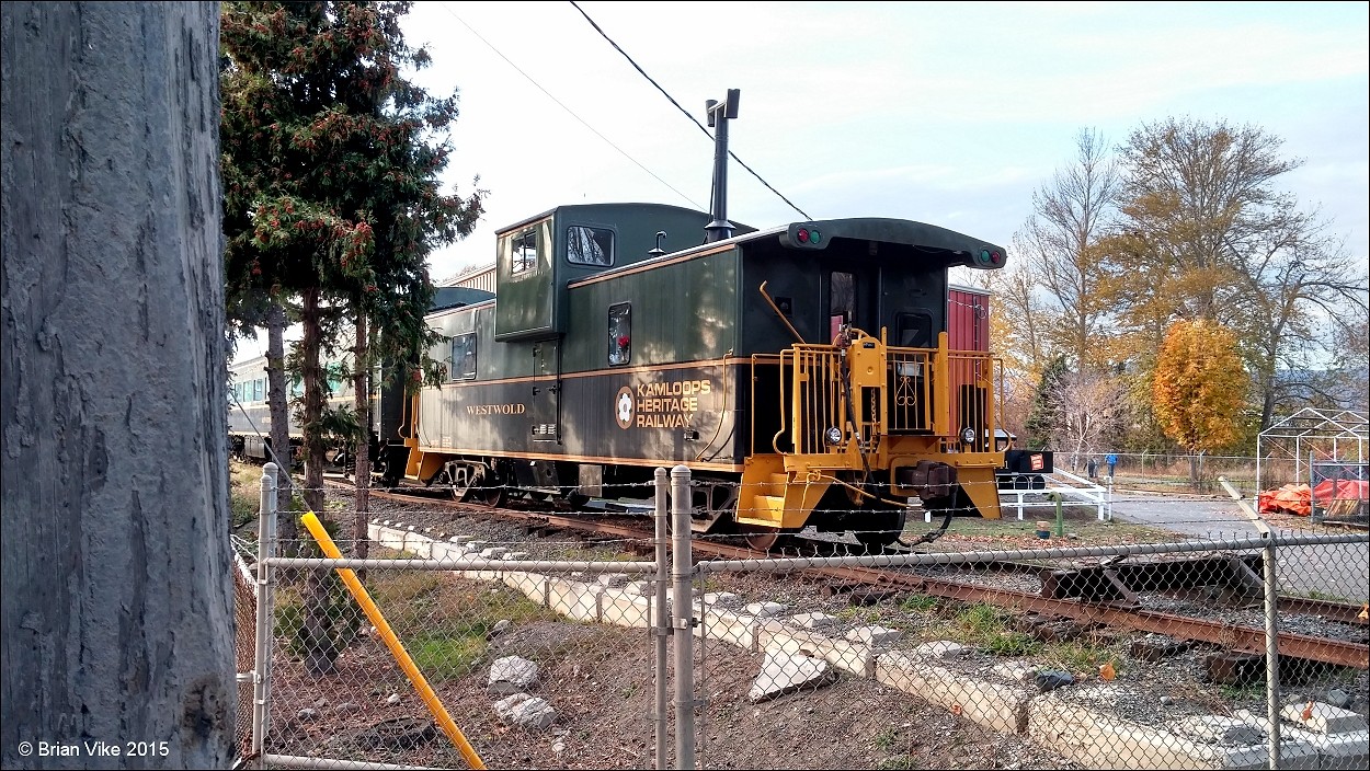
Above Photo: Another great Mural of a train found in the same area.
The January mean temperature is −2.8 °C (27 °F). That average sharply increases with an average maximum temperature of 4.3 °C (40 °F) in February. The average number of days below −10 °C (14 °F) per year is 19.9 as recorded by Environment Canada.
Above Photo: Another great Mural of a train found in the same area.
Although Kamloops is located above 50° north latitude, summers are warmer than in many places at lower latitudes, with prevailing dry and sunny weather. Daytime humidity is generally under 40% in the summer, sometimes dropping below 20% after a dry spell, which allows for substantial nighttime cooling. Occasional summer thunderstorms can create dry-lightning conditions, sometimes igniting forest fires which the area is prone to.
Kamloops lies in the rain shadow leeward of the Coast Mountains and is biogeographically connected to similar semi-desert areas in the Okanagan region, and a much larger area covering the central/eastern portions of Washington, Oregon and intermontane areas of Nevada, Utah and Idaho in the US.
Above Photo: Another great Mural of a train found in the same area.
These areas of relatively similar climate have many distinctive native plants and animals in common, such as ponderosa pine (Pinus ponderosa), big sagebrush (Artemisia tridentata), prickly pear cactus (Opuntia fragilis in this case), rattlesnakes (Crotalus viridis), black widow spiders and Lewis's woodpecker.
The hottest temperature ever recorded at the airport, 40.7 °C (105 °F), occurred on 13 July 2014; the hottest reliably accurate temperature ever recorded within the city, 41.7 °C (107 °F), occurred first on 27 July 1939 and again two years later on 16 July 1941.
Above Photo: Another great Mural of a train found in the same area.
Sports:
Kamloops hosted the 1993 Canada Summer Games. It co-hosted (with Vancouver and Kelowna) the 2006 IIHF World U20 Championship from 26 December 2005, to 5 January 2006. It hosted the 2006 BC Summer Games. In the summer of 2008, Kamloops, and its modern facility the Tournament Capital Centre, played host to the U15 boys and girls Basketball National Championship. The city is known as, and holds a Canadian trademark as, Canada's Tournament Capital.
Sun Peaks Resort is a nearby ski and snowboard hill. Olympic medallist skier Nancy Greene is director of skiing at Sun Peaks and the former chancellor of Thompson Rivers University. The Overlander Ski Club runs the Stake Lake cross country ski area with 50 km (31 mi) of trails.
Above Photo: Another great Mural of a train found in the same area.
Kamloops is home to world-famous mountain bikers such as freeride pioneers and Mountain Bike Hall of Fame members Wade Simmons, Brett Tippie, (also a former Canadian National Team member for snowboard cross and giant slalom), Richie Schley. Also home to freeriders Matt Hunter, and Graham Agassiz.
Kamloops was featured in the first mountain bike film by Greg Stump, "Pulp Traction", and later the first three "Kranked" films, which starred the original Froriders, Tippie, Simmons and Schley. In 2007, the Kamloops Bike Ranch opened in Juniper Ridge along Highland Drive. The Kamloops Rotary Skatepark located at McArthur Island Park is one of the largest skateboard parks in Canada. Also located at McArthur Island Park is NorBrock Stadium.
Kamloops is home to the Western Hockey League's Kamloops Blazers who play at the Interior Savings Centre. Alumni of the Kamloops Blazers include Mark Recchi, Jarome Iginla, Darryl Sydor, Nolan Baumgartner, Shane Doan, Scott Niedermayer, Rudy Poeschek and Darcy Tucker.
Two-time champion coach Ken Hitchcock would later win the Stanley Cup with the Dallas Stars. Lacrosse teams include the Thompson Okanagan Junior Lacrosse League's Kamloops Junior B Rattlers, as well as the Kamloops Storm.
Above Photo: Another great Mural from around Kamloops, B.C.
Also calling Kamloops home is the Canadian Junior Football League's Kamloops Broncos, and Pacific Coast Soccer League's Kamloops Excel, both of whom play at Hillside Stadium.
Soccer for the city includes: Kamloops Youth Soccer Association, Kamloops Blaze rep team and the Kamloops Excel (see above). TRU hosts the Thompson Rivers WolfPack, and has sports teams that include men's and women's volleyball, basketball, soccer and badminton. Also the WolfPack have hockey, rugby, badminton, golf and baseball teams.
Kamloops hosted the World Masters Indoor Championships 2010 on 1–6 March 2010.
Kamloops hosted the 2011 Western Canada Summer Games.
On February 6, 2016, Kamloops will host Hockey Day in Canada with Ron MacLean and Don Cherry.
Travel British Columbia with Brian Vike blog, please contact me at
b_vike@telus.net
Travel British Columbia with Brian Vike.
Travel Houston, British Columbia with Brian Vike.