Above Photo: Visitors Centre in Hope, British Columbia. What a great place to visit.
With all my travels through Hope on Highway 1 driving up the Fraser Canyon, I rarely stopped in Hope to take advantage of the wonderful things Hope, B.C. had to offer.
One of the gems in Hope is their Rotary Centennial Park. It is beautiful and is a wonderful place to get out to stretch your legs, or stop for a picnic lunch.
There are tables and benches for you to sit as you watch the mighty Fraser River flow on by. You can also view the chainsaw carvings that are located in the park, and throughout the town.
So if you are planning out a holiday and the route takes you through Hope, B.C., take the time to wander around the town as it has a lot to offer.
Left Photo: Sign which names some of the surrounding mountains and their elevation.
For tourist information, please visit the Hope, B.C. Visitors Centre:
The below text is from Wikipedia,
the free encyclopedia:
Hope is a district municipality located at the confluence of the Fraser and Coquihalla rivers in the province of
British Columbia, Canada.
Hope is at the eastern end of both the Fraser Valley and the Lower Mainland region, and is at the southern end of the Fraser Canyon.
To the east over the Cascade Mountains is the Interior region, beginning with the Similkameen Country on the farther side of the Allison Pass in Manning Park. Located 154 kilometres (96 mi) east of Vancouver, Hope is at the southern terminus of the Coquihalla Highway and the western terminus of the Crowsnest Highway, locally known as the Hope-Princeton (Highways 5 and 3, respectively), where they merge with the Trans-Canada Highway (Highway 1).
Hope is at the eastern terminus of Highway 7. Hope is a member municipality of the Fraser Valley Regional District which provides certain municipal services to unincorporated settlements and rural areas.
The District of Hope includes Hope Townsite (the previous Town of Hope) and surrounding areas including the communities of Kawkawa Lake, Silver Creek, Flood, and Lake of the Woods.
Above Photo: Just one of the many wonderful chainsaw carvings in Hope, B.C.
Hope is at the easternmost point of British Columbia's lower mainland area and is usually considered to be part of the Fraser Canyon area or "eastern Fraser Valley" as "Lower Mainland" is commonly understood as synonymous with "greater Vancouver".
Above Photo: Highway information sign next to the Rotary
Centennial Park in Hope, B.C.
There are relatively significant peaks to the north, east, and south of the townsite. Only to the west can flat land be seen, and that view is dominated by the broad lower reaches of the Fraser River. The segment from Lytton to Hope separates the Cascade Mountains and Coast Mountains, thereby forming the lower part of the Fraser Canyon, which begins far upriver near Williams Lake.
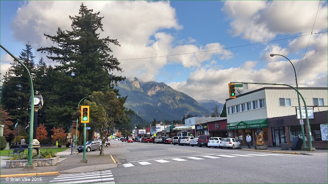
Above Photo: Downtown Hope, British Columbia Canada.
At Hope, the river enters a broad flood plain extending 130 kilometres (81 mi) to the coast and Vancouver. The Coquihalla and Sumallo Rivers and Silverhope Creek rise in the Cascade Mountains northeast and southeast and south of Hope, respectively, and empty into the Fraser River.
The Skagit River begins south of Hope, across a low pass from the head of the Silverhope valley, which is the access to the Canadian shoreline of Ross Lake.
Above Photo: Folks enjoying the view of the Fraser River from the Rotary Centennial Park.
Travel British Columbia with Brian Vike blog, please contact me at b_vike@telus.net
Travel Houston, British Columbia with Brian Vike.


No comments:
Post a Comment